From August 23, 2006 through October 3, 2006, we posted updates on Arctic sea ice conditions. To view previous updates, scroll down to see a specific entry.
03 October 2006: 2006 Arctic Sea Ice Minimum
The 2006 sea ice melting season is coming to a close. Please see the NSIDC Press Release, Arctic Sea Ice Shrinks as Temperatures Rise, for analysis of this year’s Arctic sea ice minimum.
27 September 2006
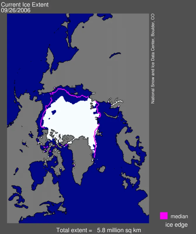
Overview of current sea ice conditions: Sea ice extent has remained fairly steady over the past week.
Past updates speculated on possible mechanisms to explain the formation of the polynya, which at its maximum extent in early September was roughly the size of Indiana. We speculated that anomalous winds may have forced divergence of the ice cover, causing the opening to form.
We recently discussed this idea with two of our colleagues, David Douglas at the United States Geological Survey’s Alaska Science Center in Juneau, and Ignatius Rigor at the University of Washington in Seattle. An alternative scenario that emerged from our discussions is that winds and ocean currents may have transported unusually thin ice into the Beaufort Sea over the past winter; this summer, the thin ice melted out to form the polynya. A slant on this hypothesis is that the thin ice, being relatively weak, would also have been especially susceptible to breakup by winds.
Given the interest in this unusual polynya, a more formal study is warranted.
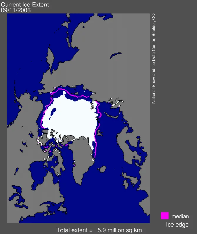
White indicates areas where sea ice is present. Areas in blue are open ocean, while gray indicates land masses. The pink line shows the average ice extent for September, the end of the summer melt season. The September average is calculated from 1979 through 2000.
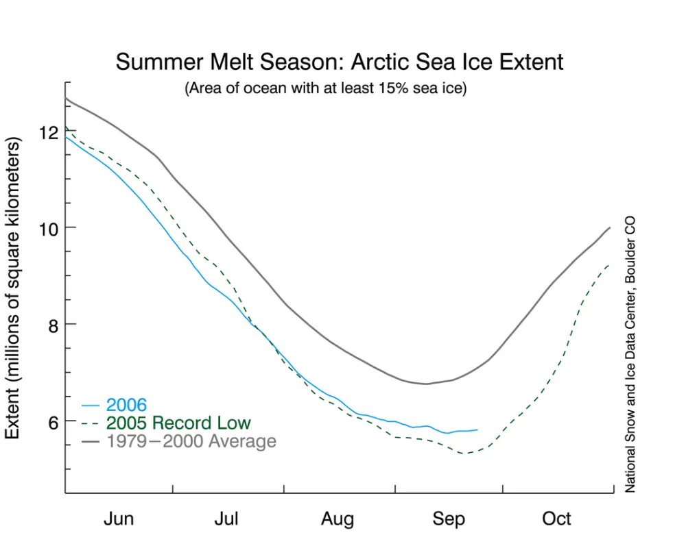
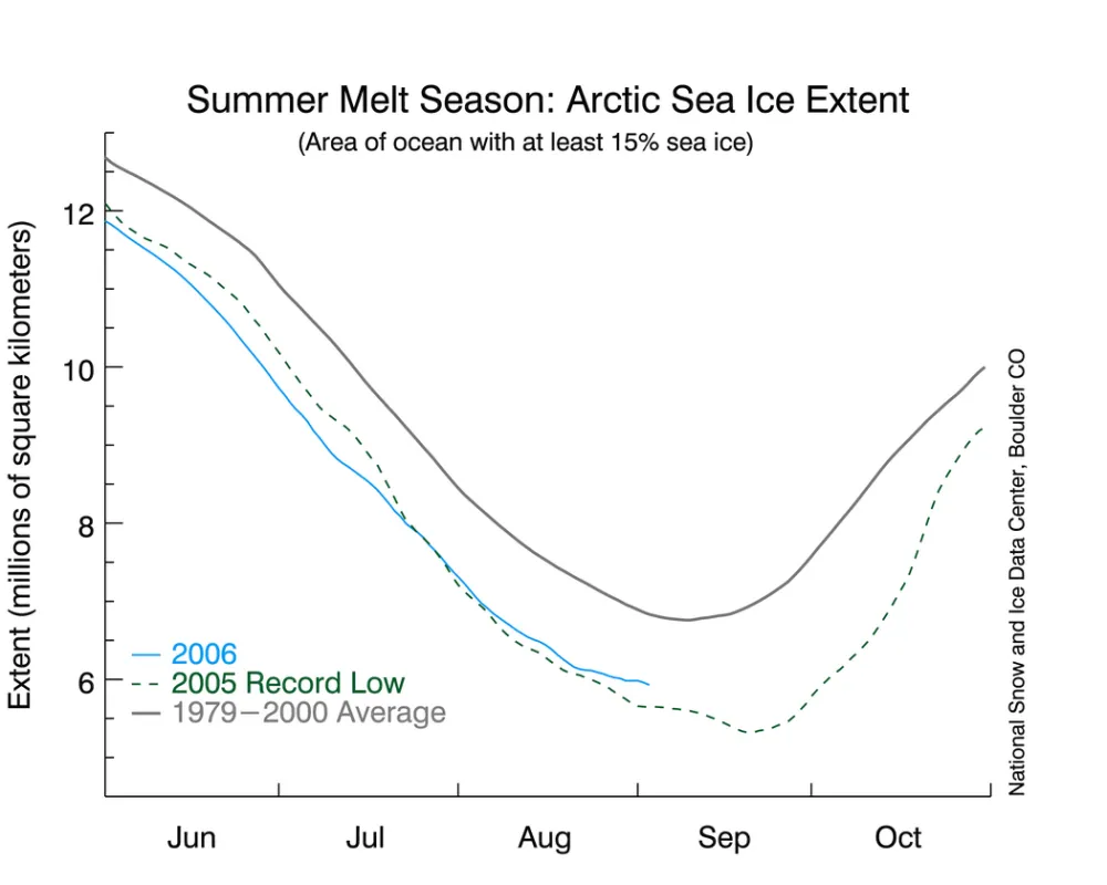
Current sea ice conditions in context: It is still too early to state conclusively whether we have reached the sea ice minimum extent. As is evident in the figure above showing the updated time series, sea ice extent for the past week or so has stayed fairly constant, with perhaps a slight increase in the past few days. Formation of new ice in some areas, such as around the Beaufort Sea polynya, is apparently being offset by continued melt, or perhaps ice convergence, in other areas.
The latest date that a minimum has occurred over the satellite record was on September 22. Given this historical perspective, we are probably past this year’s minimum; however, we will make a final determination next week, when we have the complete data for September.
Surface air temperatures for September 1 through 24, have been above average, breaking the pattern of relatively cool conditions that characterized August, and keeping 2006 on track to be another very warm year in the Arctic.
While low atmospheric pressure has still dominated the Arctic in September, the center of the action has shifted to the central Siberian coast. Offshore winds on the south side of the low appear to be pumping warm air into the Arctic, keeping temperatures fairly high.
19 September 2006
Overview of current sea ice conditions: Current sea ice conditions have been fluctuating downward since our last update; as of yesterday afternoon, we have not yet reached the sea ice minimum. If sea ice were to stop melting now, 2006 would hold fourth place for the September minimum.
Current sea ice conditions: September 18, 2006 As compared to the last report, the polynya in the Beaufort Sea has opened (figure above).
Some areas of the ocean show evidence of new ice formation as autumn cooling begins to take hold. However, at the same time, some areas south of the polynya that were formerly ice covered have continued to melt out. Total Arctic sea ice extent has declined slightly as compared to the last report, but we are probably close to the turning point in the season.
White indicates areas where sea ice is present. Areas in blue are open ocean, while gray indicates land masses. The pink line shows the average ice extent for September, the end of the summer melt season. The September average is calculated from 1979 through 2000.
Current sea ice conditions in context The figure above shows an updated time series. If current conditions represent the end of the melt season, then the September 2006 sea ice minimum would now be the fourth lowest on record (5.758 million square kilometers, or 2.22 million square miles), barely beating 2004 (5.812 million square kilometers, or 2.24 million square miles). What happens in the next week will represent a race between new ice formation in some areas and continued melt in others.
Interestingly, while the chances seem low that September 2006 will set a new record for ice extent, it is close to upsetting 2002 as the record low in terms of ice area. Ice extent is based on summing all regions with at least 15% ice concentration (15% ice and 85% open water). Ice area is the total area of ice once open water areas are removed from the calculation. In other words, ice area can be thought of as the total area of ice if it were squished together so there were no gaps.
A new record low for sea ice area would indicate that the ice pack as a whole is spread out. Much of this diffuse, low-concentration ice is in the vicinity of the polynya.
More on the Unusual Polynya The polynya mentioned in our previous reports is extremely unusual. The only time we’ve seen a similar polynya was in 2000. However, the 2000 formation was much smaller and closer to the ice edge, barely enclosed with ice.
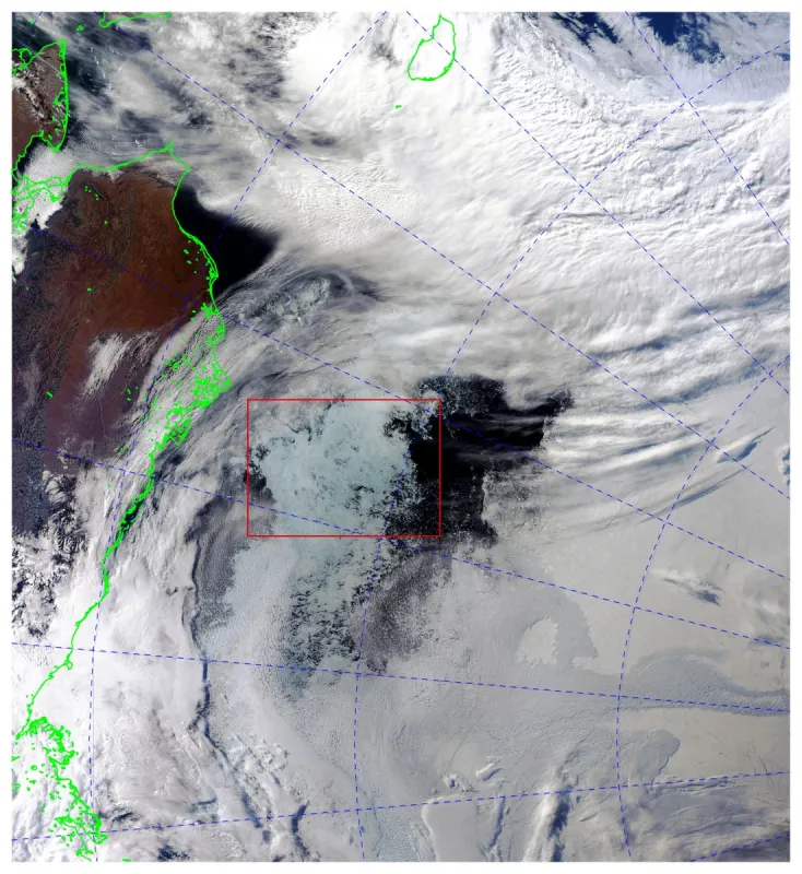
To get a better idea of what the ice near the Beaufort Sea polynya looks like, we used an image from a satellite sensor that is different than the one used to generate the first graphic. The sensor, called the Moderate Resolution Imaging Spectroradiometer (MODIS), flies on the NASA Terra and Aqua satellites.
The graphic above is a MODIS image from September 11, 2006, at 11:00 pm Greenwich Meridian Time, chosen because of nearly cloud-free conditions. Green outlines show the north coast of Alaska, ruddy with autumn color. The red box encloses the ice just south of the polynya; the polynya itself is the dark shape in the ice just to the north (right) of the red box.
The bluish tint of the ice near the polynya indicates that the ice is wet from surface melting. Cooler weather in the next several days may slow or stop the melting.
12 September 2006
Overview of current sea ice conditions: Current sea ice conditions are still well below the long-term average, but, as of yesterday, sea ice extent showed a modest increase; whether we have reached the seasonal minimum or may see further reductions is still unclear.
Current sea ice conditions: September 11, 2006 The figure above shows current sea ice extent. The most notable feature of this image is that the polynya in the Beaufort Sea has grown still larger. Closer inspection of satellite images shows that ice concentrations just south of the polynya are quite low. If this ice melts, the polynya may open up to the sea very soon and we may see further reductions in the overall sea ice extent.
White indicates areas where sea ice is present. Areas in blue are open ocean, while gray indicates land masses. The pink line shows the average ice extent for September, the end of the summer melt season. The September average is calculated from 1979 through 2000.
Current sea ice conditions in context As of yesterday, ice extent is not currently declining. The most recent data actually show a small rise. We may have already reached the September sea ice minimum extent. The relatively cool and stormy conditions that characterized August (see reports below) may have averted a repeat of the extreme ice losses of 2005. If we have reached the minimum, this year would be the fifth lowest in the satellite record.
That said, we are not at all certain that we have reached the minimum; given the precariously low ice concentrations bounding the southern edge of the Beaufort Sea polynya discussed above, ice extent may start declining again.
No matter what happens from here on, September 2006 continues the pattern of strongly below-average sea ice extent.
Our colleague, Sheldon Drobot at the University of Colorado, has developed a statistical forecasting system aimed at predicting average sea ice extent for the entire month of September (not the absolute minimum discussed above). The forecast is based on spatial patterns of multiyear sea-ice concentration from the preceding spring, as well as spatial patterns of total sea-ice concentration and surface air temperature.
Based on August data, Drobot’s group is forecasting a September average of 6.11 million square kilometers (2.4 million square miles), which would rank as the fourth lowest on record. The prediction system indicates only a 3% chance of a record minimum this year. Based on July data, they had forecasted 5.94 million square kilometers (2.3 million square miles), the second lowest on record. The difference between the forecasts is further evidence that cooler conditions in August may have helped “save” the sea ice cover.
6 September 2006
Overview of current sea ice conditions: Current sea ice conditions are still below the long-term average and above last year’s record. For more details, see below. Sea ice data are obtained from satellites; see Frequently Asked Questions for more about data sources.
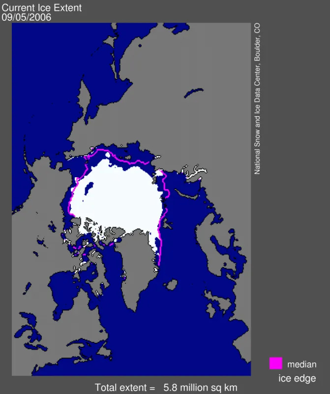
Current sea ice conditions: September 5, 2006: Compared to the last report, extent has declined only slightly. Over the past few days, extent has hovered around 6 million square kilometers (2.3 million square miles).
The unusual polynya in the Beaufort Sea is still present. A number of polynyas tend to form in the same place every year, perhaps the best-known being the “Northwater Polynya” in Baffin Bay. Such features are also common along the north coast of Canada. Often, polynyas form because of upwelling of warm water to the surface, particularly in regions far from the coast, such as the Beaufort Sea. This could be possible in the case of the Beaufort Sea polynya; however, it is more likely caused by atmospheric circulation forcing a local divergence of ice. We have never seen a large polynya in the Beaufort Sea, and it is not entirely clear how it formed.
White indicates areas where sea ice is present. Areas in blue are open ocean, while gray indicates land masses. The pink line shows the average ice extent for September, the end of the summer melt season. The September average is calculated from 1979 through 2000.
Current sea ice conditions in context
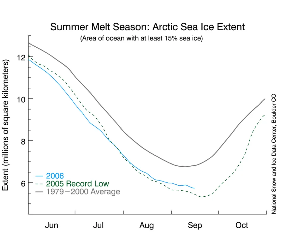
The updated timeline of sea ice conditions above shows that the slowing of ice loss has continued.
If the sea ice were to stop shrinking now, it would probably be the 8th lowest of the 28-year satellite record. However, it is still premature to come to any conclusions. For example, looking back at 2005, it seemed that ice loss had ceased around the second week of September, only to decline again the next week.
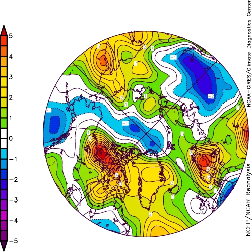
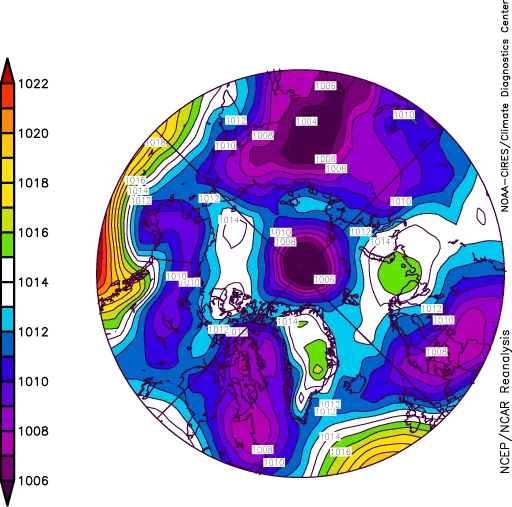
The graphic above shows the average atmospheric pressure at sea level for August. The salient feature is a pronounced average low-pressure area just off the pole, shown in dark purple. While such a pattern is fairly common in the summer Arctic, the average low in August was especially strong. Air temperatures beneath such lows are typically colder than average; the results in the graphic above, fit this pattern.
Surface winds around the low-pressure system blow counterclockwise. The balance of forces on the ice, when the winds are blowing this way, promotes ice divergence. This spreads the ice over a larger area. Note that clockwise winds promote convergence, packing the existing ice into a smaller area.
The combination of cooler temperatures and counterclockwise winds helps explain the slower sea ice losses in August 2006 as compared to last year, when the central Arctic Ocean was not as stormy. Understanding year-to-year variations in storminess over the Arctic Ocean is a subject of ongoing research at NSIDC.
The NOAA Live from the North Pole Web cam offers photographs showing near-real-time conditions near the pole. The latest image shows low clouds and poor visibility, typical for this time of year. Perhaps conditions may clear in the near future; if so, the Web cam would provide good idea of sea ice conditions in the area.
30 August 2006
Overview of current sea ice conditions: Current sea ice conditions are still below the long-term average and slightly above last year’s record.
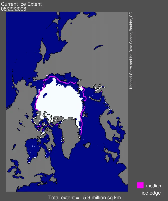
Current sea ice conditions: August 29, 2006 Sea ice extent continues to decline as the melt season progresses. The unusual polynya in the Beaufort Sea, noted in the previous report, has gotten somewhat larger. While the ice has retreated poleward of its September average in most places, it is still outside of the September average off the western part of Alaska. The strongest ice retreats since our last report are along parts of the Russian coast.
White indicates areas where sea ice is present. Areas in blue are open ocean, while gray indicates land masses. The pink line shows the average ice extent for September, the end of the summer melt season. The September average is calculated from 1979 through 2000.
Current sea ice conditions in context The rate of ice loss has slowed slightly compared to our last report. If this slowing were to continue, sea ice extent in 2006 would not set a new record low. However, conditions may change over the next few weeks.
Two factors help explain the slower ice loss compared to 2005. First, air temperatures in August have not been especially warm; in some areas, conditions have even been slightly cooler than normal. This contrasts with the unusual warmth from January through July.
Second, low atmospheric pressure, centered slightly off the North Pole, has dominated the area during August. Low pressure favors extensive cloud cover, which in summer moderates temperatures. Finally, the counterclockwise winds that dominate the low-pressure region tend to spread the ice over a larger area. However, the ice will then be present in lower concentrations, with more open water between floes.
23 August 2006
Overview of current sea ice conditions Current sea ice conditions are below average and are closely tracking last year’s record low.
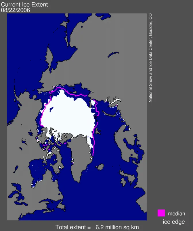
Current sea ice conditions: August 22, 2006 The figure above shows current sea ice extent. White indicates areas where sea ice is present. Areas in blue are open ocean, while gray indicates land masses. The pink line shows the average ice extent for September, the end of the summer melt season. The September average is calculated from 1979 through 2000. We see that over most parts of the Arctic, the sea ice has already retreated poleward of where it should be for an average September. However, the projected sea ice minimum is still several weeks into the future. That said, the ice extent for August 22 is slightly greater than observed last year at the same time (see figure below). 2005 was the record minimum sea ice extent. The Northwest Passage, through the channels of the Canadian Arctic Archipelago, is essentially clear. An unusual polynya, an irregularly shaped area of open water, has appeared north of Alaska in the Beaufort Sea.
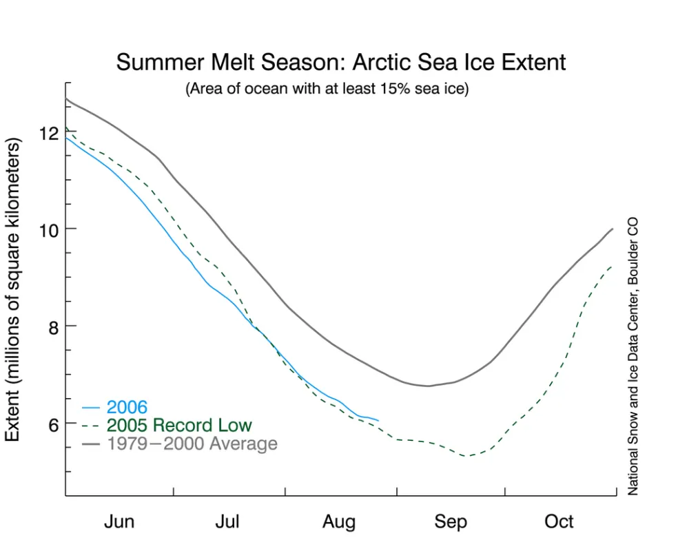
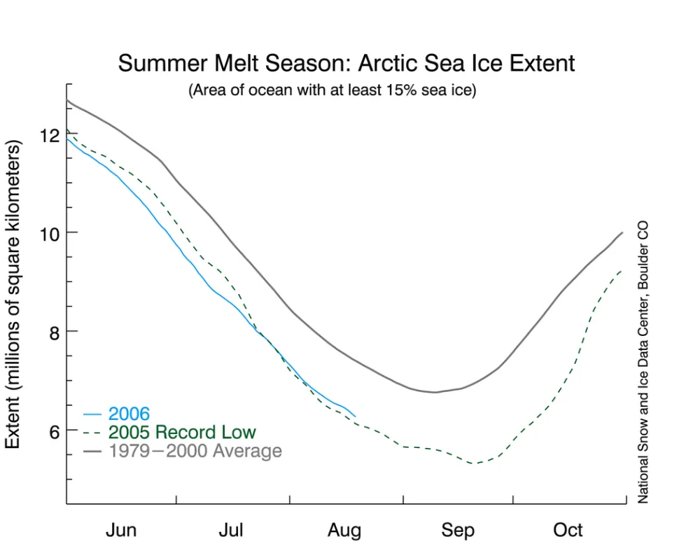
Current sea ice conditions in context As the figure above shows, current sea ice extent, shown in solid blue, is well below the average for 1979-2000, which is shown in solid gray. However, slightly more sea ice is present now than this time last year, indicated by the dashed green line.
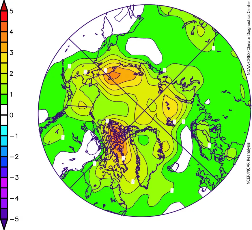
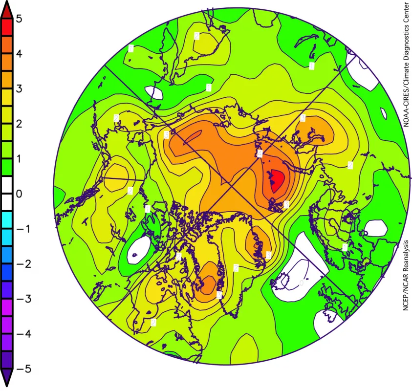
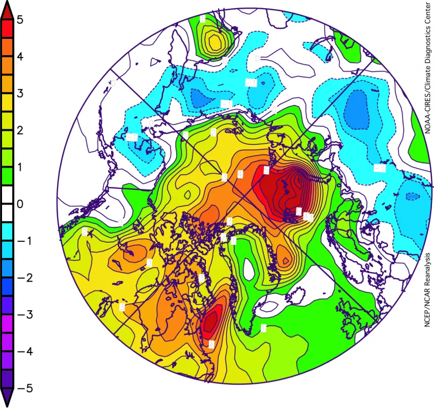
Warm temperatures contribute to ice loss Unusually high air temperatures over the Arctic help to explain the ongoing decline of sea ice. Why? First, the warmer Arctic is helping to melt more ice in summer, and inhibiting ice growth in the winter. Second, as we begin to lose the sea ice cover, the ocean releases more heat into the lower atmosphere. Put differently, the warmer Arctic leads to less sea ice, and the loss of sea ice contributes to a warmer Arctic. The first anomaly graphic shows surface air temperature anomalies from 2000 to 2005. The scale goes from red for temperatures strongly above average to blue/purple for temperatures strongly below average. These anomalies show temperatures compared to the average for 1968 to 1996.Temperatures from 2000 to 2005 were from 1 to 3 degrees Celsius (2 to 5 degrees Fahrenheit) higher than average. Note that there are essentially no areas with unusually low temperatures. The middle graphic shows temperature anomalies for only 2005, which was the record low year for sea ice. For the globe as a whole, 2005 was tied for the warmest year on record. The year 2005 was especially warm in the Arctic, with temperatures 2 to 4 degrees Celsius (4 to 7 degrees Fahrenheit) above normal. The 2006 Arctic temperature anomalies graphic above shows that the warm trend has continued in 2006, which does not bode well for the sea ice.
