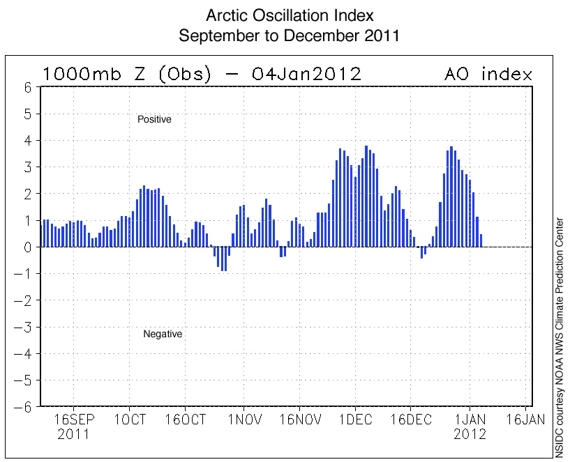
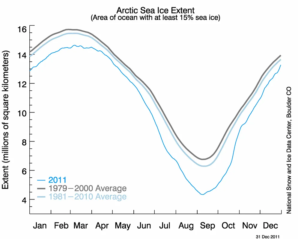
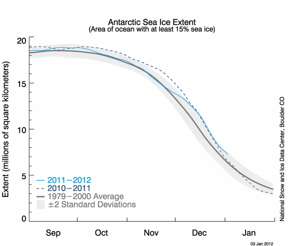
Arctic sea ice extent remained unusually low through December, especially in the Barents and Kara seas. In sharp contrast to the past two winters, the winter of 2011 has so far seen a generally positive phase of the Arctic Oscillation, a weather pattern that helps to explain low snow cover extent and warmer than average conditions over much of the United States and Eastern Europe. In Antarctica, where summer is beginning, sea ice extent is presently above average.
Overview of Conditions
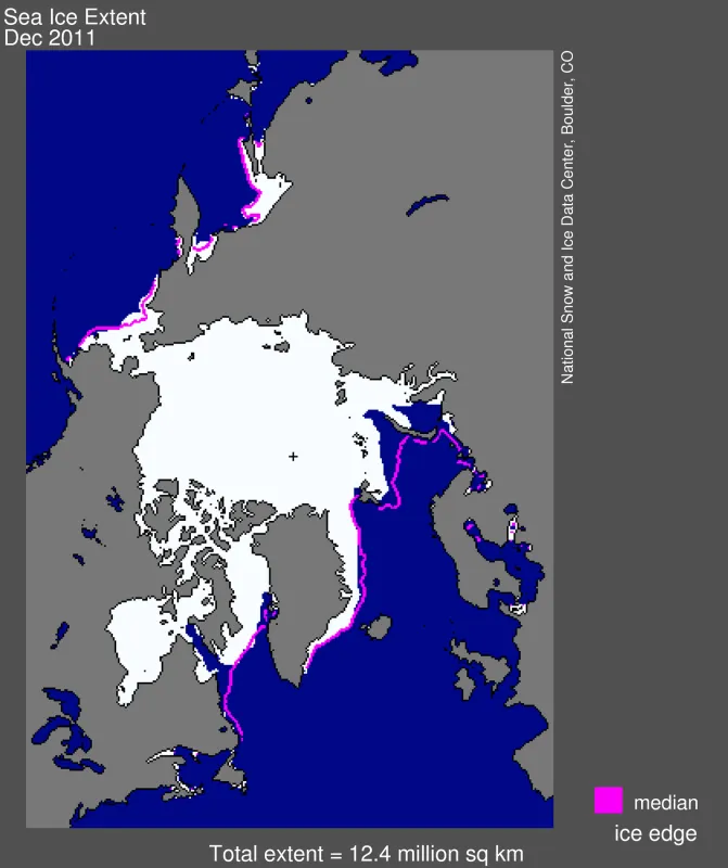
Arctic sea ice extent in December 2011 averaged 12.38 million square kilometers (4.78 million square miles). This is the third lowest December ice extent in the 1979 to 2011 satellite data record, 970,000 square kilometers (375,000 square miles) below the 1979 to 2000 average extent.
Ice extent was particularly low on the Atlantic side of the Arctic, most notably in the Barents and Kara seas. The eastern coast of Hudson Bay did not freeze entirely until late in the month: normally, Hudson Bay has completely frozen over by the beginning of December. In the Bering Sea, ice extent was slightly above average.
Conditions in context
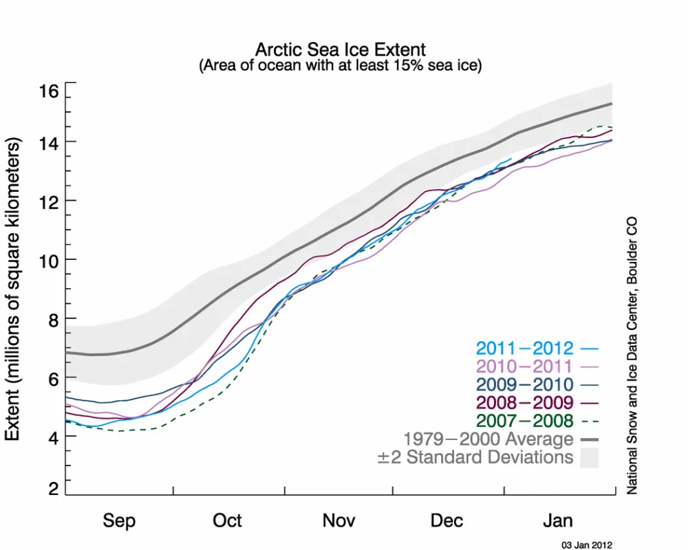
For the Arctic as a whole, ice extent for the month remained far below average. The Arctic sea ice cover grew slightly faster than average, but December started out with a lower-than-average ice extent.
Overall, the Arctic gained 2.37 million square kilometers (915,000 square miles) of ice during the month. The average ice gain for December was 1.86 million square kilometers (718,000 square miles). On December 31, Arctic sea ice extent was 13.25 million square kilometers (5.12 million square miles), 561,000 square kilometers (217,000 square miles) more than the ice extent on December 31, 2010, the lowest extent on December 31 in the satellite record.
December 2011 compared to past years
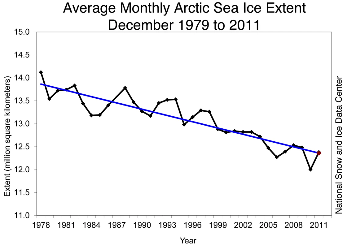
Arctic sea ice extent for December 2011 was the third lowest in the satellite record. The five lowest December extents in the satellite record have occurred in the past six years. Including the year 2011, the linear rate of decline ice December ice extent over the satellite record is -3.5% per decade.
Arctic temperatures
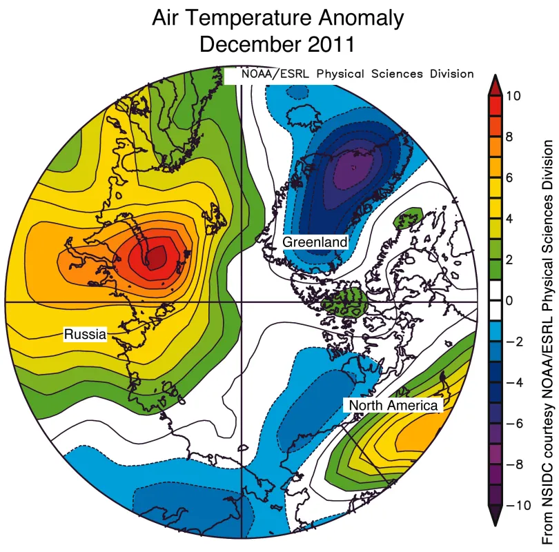
Air temperatures in December were lower than average over much of the Arctic Ocean, but higher than average over the Kara and Barents seas. Higher-than-average temperatures in these regions stemmed from two major factors. First, where sea ice extent is low, heat can escape from areas of open water, warming the atmosphere. Second, surface winds in the Kara and Barents Sea ice blew persistently from the south, bringing in heat from lower latitudes. This imported heat also helped to keep sea ice extent low in this area. Conditions over Canada were also unusually warm during December, but conditions over southeast Greenland have been 6 to 8 degrees Celsius (11 to 14 degrees Fahrenheit) colder than average, partly because of northerly winds in the area.
Positive phase of the Arctic Oscillation
The past two Arctic winters were dominated by a negative phase of the Arctic Oscillation, a large-scale weather pattern that brings generally warm conditions to the Arctic and colder conditions to Europe and North America. In contrast, the winter of 2011 has so far seen a mostly positive phase of the Arctic Oscillation. While temperatures were above normal in the Kara and Barents seas, the positive phase of the Arctic Oscillation tends to keep the coldest winter air locked up in the Arctic, which keeps the middle latitudes free of frigid Arctic temperatures and strong snowstorms. This weather pattern helps to explain the low snow cover and warm conditions over much of the United States and Eastern Europe so far this winter.
Several studies have shown that during the positive phase of the Arctic Oscillation, thick ice tends to move out of the Arctic through Fram Strait, leaving the Arctic with thinner ice that melts out more easily in summer. Scientists will be watching closely for this connection if the positive phase of the Arctic Oscillation continues through the winter.
Some scientists have speculated that the negative Arctic Oscillation pattern of the last two winters was in part driven by low sea ice extent. The recurrence of the positive phase of the Arctic Oscillation so far this winter, following a near-record low summer sea ice extent, suggests that other factors play an important role.
2011 year in review
Arctic sea ice extent fell to its seasonal minimum on September 9, 2011, falling just short of the record low set in September 2007, when summer weather conditions were extremely favorable for ice loss. This summer, the weather was not as extreme as 2007, so it was surprising that ice extent dropped so low. The low ice extent, along with data on ice age, suggests that the Arctic ice cover remains thin and vulnerable to summer melt.
Northern Hemisphere snow cover retreated very rapidly last spring, with record and near-record low snow cover extents in May and June despite higher-than-average winter snow extent as of February and March.
A quick look at Antarctica
After a particularly slow ice loss rate at the beginning of the month, Antarctic sea ice extent was unusually high through much of December, in particular in the northern Ross Sea and the eastern Weddell Sea. December and November have had a markedly strong Amundsen Sea Low, an atmospheric pressure pattern that tends to spread the sea ice cover northward in the Ross Sea. Low pressure over the eastern Weddell Sea later in the month had the same effect there. Sea ice for the Antarctic in December 2011 was the fifth-highest for that month in the satellite record; the highest December extent occurred in 2007. Overall though, Antarctic sea ice extent remained below or near normal for most of 2011. Antarctic sea ice data are available on the Sea Ice Index website.
References
Rigor, I. G., and J. M. Wallace. 2004. Variations in the age of Arctic sea-ice and summer sea-ice extent, Geophys. Res. Lett., 31, L09401, doi:10.1029/2004GL019492.
