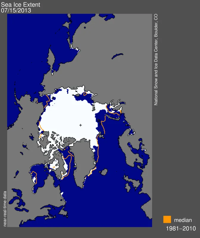
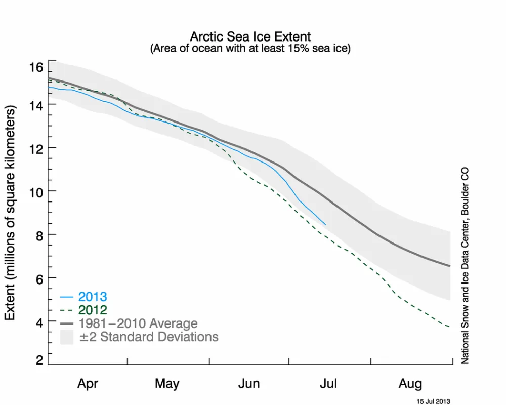
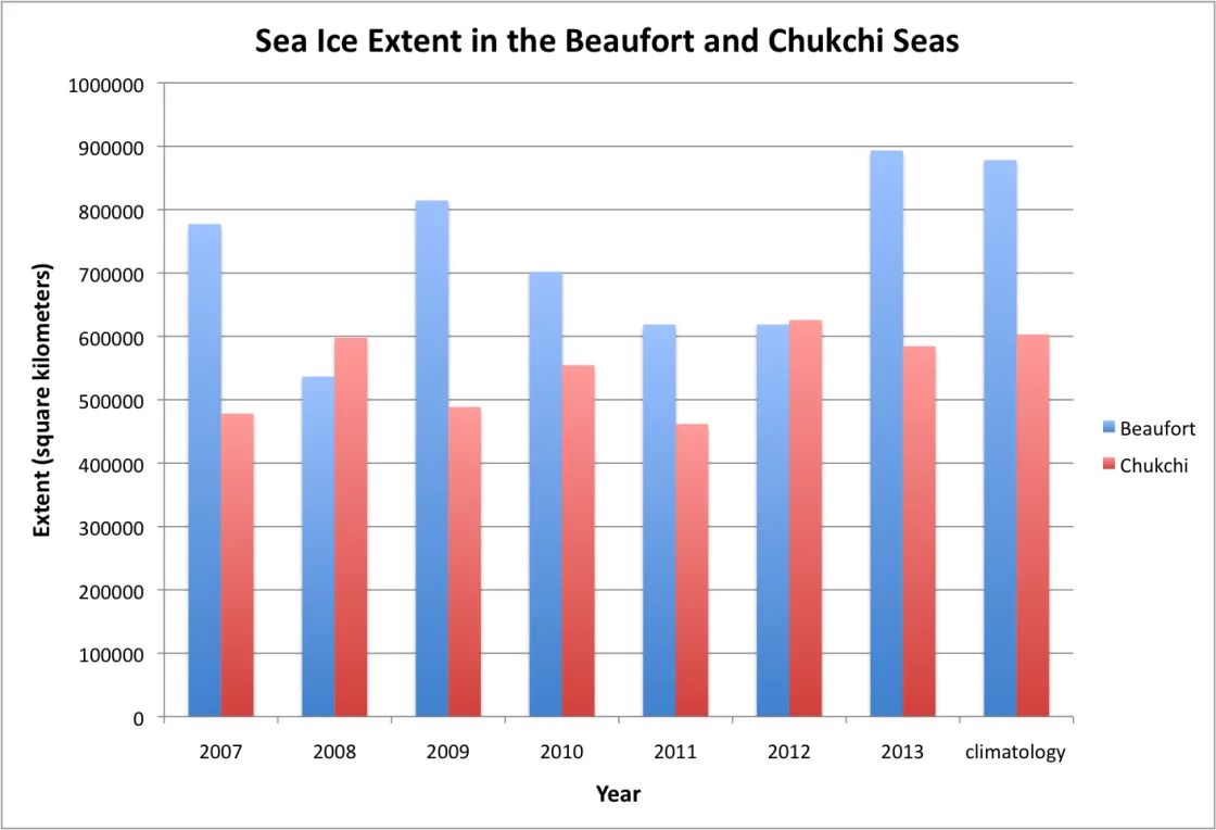
Sea ice extent retreated fairly rapidly through the first two weeks of July as a high pressure cell moved into the central Arctic, bringing warmer temperatures over much of the Arctic Ocean. Ice extent remains below average on the Atlantic side of the Arctic, and is near average to locally above average in the Beaufort and Chukchi seas and along much of the Eurasian coast.
Overview of conditions
While the rate of Arctic sea ice loss is normally fastest during July, the warmest month of the year, ice loss was even faster than usual over the first two weeks of July 2013. As a result, on July 15 extent came within 540,000 square kilometers (208,000 square miles) of that seen in 2012 on the same date. The ice loss is dominated by retreat on the Atlantic side of the Arctic, including the East Greenland, Kara and Laptev seas, and Baffin Bay. In the Beaufort and Chukchi seas and much of the Eurasian coast, the ice cover remains fairly extensive, especially compared to recent summers. Compared to the 1981 to 2010 average, ice extent on July 15, 2013 was 1.06 million square kilometers (409,000 square miles) below average.
Conditions in context
During the first two weeks of July, ice extent declined at a rate of 132,000 square kilometers (51,000 square miles) per day. This was 61% faster than the average rate of decline over the period 1981 to 2010 of 82,000 square kilometers (32,000 square miles) per day. The fast pace of ice loss was dominated by retreat in the Kara and East Greenland seas, where the ice loss rate from July 1 to 12 was -16,409 and -17,678 square kilometers (-6,336 and -6,826 square miles) per day, respectively. The Laptev Sea ice retreated at about half that rate, at -8,810 square kilometers (-3,402 square miles) per day. In contrast, on the Pacific side, sea ice has been slow to retreat. During the first part of July, the rate of ice loss in the Beaufort and Chukchi seas was only -3,375 and -6,829 square kilometers (-1,303 and -2,637 square miles), respectively.
A change in the weather
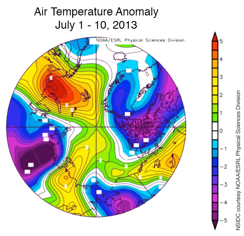
Temperatures at the 925 hPa level for the first two weeks in July were 1 to 3 degrees Celsius (2 to 5 degrees Fahrenheit) above average over much of the Arctic Ocean and as much as 5 degrees Celsius (9 degrees Fahrenheit) above average over the Kara Sea, where ice loss was pronounced. In contrast, temperatures over Alaska, Siberia and the Canadian Arctic were 3 to 5 degrees Celsius (5 to 9 degrees Fahrenheit) lower than average.
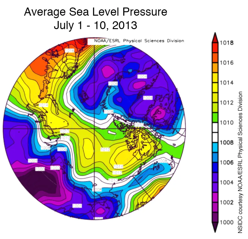
Warmer conditions have been paired with a shift in the atmospheric circulation, with a high pressure cell at sea level pressure moving into the central Arctic, replacing then pattern of low pressure that dominated the month of June. This has helped to bring in warm air from the south over the Arctic Ocean. This pattern has also helped to create open water areas in the Laptev Sea because offshore winds push the ice away from shore.
Slow ice retreat along coastal Alaska and Canada
The slow retreat of sea ice in the Beaufort Sea has resulted in the most extensive ice cover seen there in the last seven summers (Figure 4). Ice extent also remains rather extensive in the Chukchi Sea, though other recent years have seen more ice at this same time of year, particularly in 2012, when Shell was forced to delay drilling operations and reduce the number of wells planned. Despite extensive ice cover, visible imagery from the Moderate Resolution Imaging Spectroradiometer (MODIS) satellite instrument shows melt is well underway.
