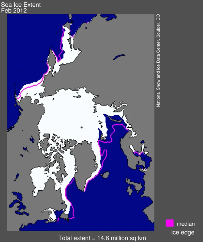
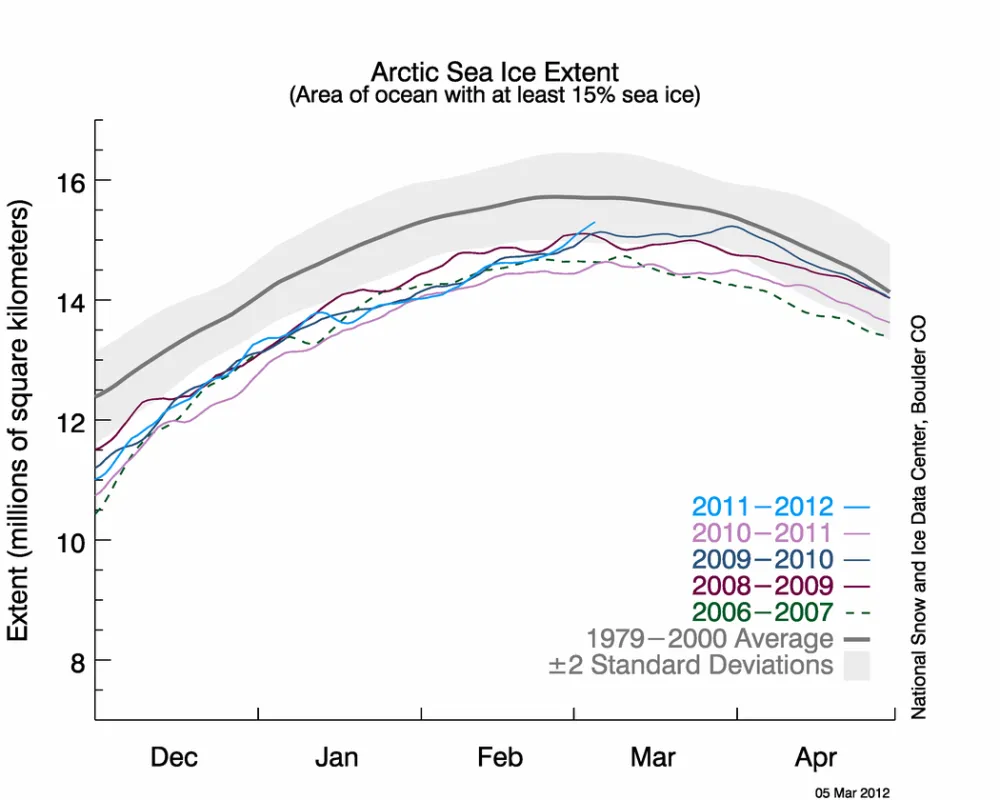
As in January, sea ice extent in February was low on the Atlantic side of the Arctic, but unusually high on the Pacific side of the Arctic, remaining lower than average overall. At the end of the month, ice extent rose sharply, as winds changed and started spreading out the ice cover.
Sea ice extent in late winter can go up and down very quickly, getting pushed together or dispersed by strong winds. Ice extent usually reaches its annual maximum sometime in late February or March, but the exact date varies widely from year to year.
Overview of conditions
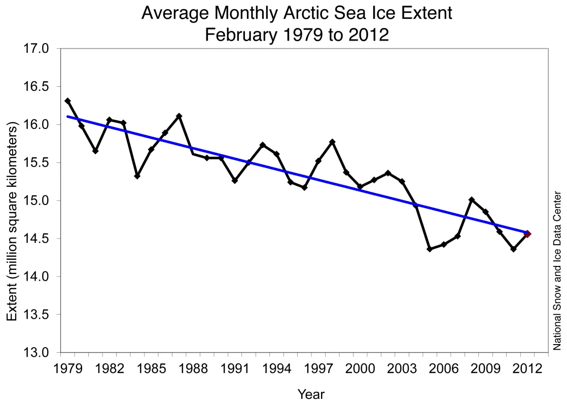
Arctic sea ice extent in February 2012 averaged 14.56 million square kilometers (5.62 million square miles). This is the fifth-lowest February ice extent in the 1979 to 2012 satellite data record, 1.06 million square kilometers (409,000 square miles) below the 1979 to 2000 average extent.
Continuing the pattern established in January, conditions differed greatly between the Atlantic and Pacific sides of the Arctic. On the Atlantic side, especially in the Barents Sea, air temperatures were higher than average and ice extent was unusually low. February ice extent for the Barents Sea was the lowest in the satellite record. Air temperatures over the Laptev, Kara and Barents seas ranged from 4 to 8 degrees Celsius (7 to 14 degrees Fahrenheit) above average at the 925 hectopascal (hPa ) level (about 3000 feet above sea level). In contrast, on the Pacific side, February ice extent in the Bering Sea was the second highest in the satellite record, paired with air temperatures that were 3 to 5 degrees Celsius (5 to 9 degrees Fahrenheit) below average at the 925 hPa level.
Conditions in context
Overall, the Arctic gained 956,000 square kilometers (369,000 square miles) of ice during the month. This was 486,000 square kilometers (188,000 square miles) more than the average ice growth for February 1979 to 2000. The overall low ice extent for the month stemmed mostly from the low ice extent in the Barents Sea: the extensive ice in the Bering Sea was not enough to compensate. On average, the Barents Sea has 865,000 square kilometers (334,000 square miles) of ice for the month of February. This year there were only 401,000 square kilometers (155,000 square miles) of ice in that region, the lowest recorded in the satellite data record.
At the end of February, ice extent rose sharply. Data from the NSIDC Multisensor Analyzed Sea Ice Extent (MASIE) showed that the rise came mainly from the Bering Sea and Baffin Bay. In the Bering Sea and Baffin Bay, winds pushed the ice extent southward. Ice growth in the Kara Sea also contributed to the rise in ice extent. In the Kara Sea, westerly winds that had been keeping the area ice-free shifted, allowing the open water areas to freeze over. During late winter, ice extent can change quickly as winds push extensive ice cover together, or spread out ice floes over a greater area.
February 2012 compared to past years
Arctic sea ice extent for February 2012 was the fifth lowest in the satellite record. Including the year 2012, the linear rate of decline for February ice extent over the satellite record is 3.0% per decade. Based on the satellite record, through 2003, average February ice extent had never been lower than 15 million square kilometers (5.79 million square miles). February ice extent has not exceeded that mark eight out of the nine years since 2003.
IceBridge thickness data
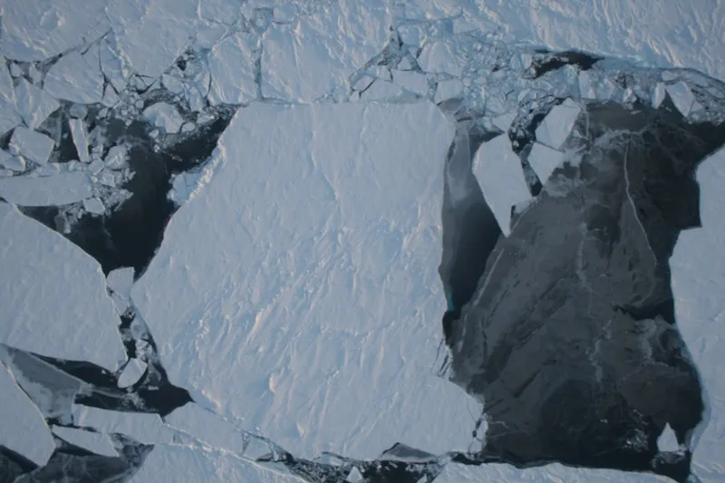
Measuring ice thickness is critical to assessing the overall health of Arctic sea ice. The passive microwave data that NSIDC presents here provide only ice extent, a two-dimensional measure of ice cover. But ice can vary in thickness from a few centimeters to several meters, and scientists want to know if the ice pack is thinning overall as well as declining in extent. A new study by NASA scientist Ron Kwok compared ice thickness data collected by airplanes during the ongoing Operation IceBridge with thickness data from the NASA Ice, Cloud and Land Elevation Satellite (ICESat), which ended its mission in 2009. IceBridge is an airborne data-collection mission that started in 2009, in order to bridge the data gap between the first ICESat and ICESat-2, which is scheduled to launch in 2016.
Kwok found good agreement between simultaneous IceBridge and ICESat freeboard measurements made in 2009. Freeboard is the elevation of sea ice above the ocean surface, and provides a measure of ice thickness. These results show that IceBridge measurements will be able to bridge the gap between the ICESat and ICESat-2 satellite missions and add to other ice thickness data from the European Space Association (ESA) Cryosat-2. Satellite measurements of ice thickness provide a third dimension of information on the changing sea ice cover, helping scientists to more accurately assess the amount of sea ice in the Arctic.
Data collected by the IceBridge mission is archived and distributed by the NASA NSIDC DAAC.
Regional ice conditions and harp seals
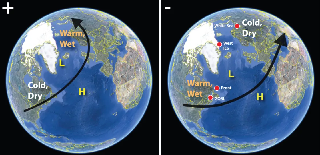
Many animals rely on sea ice as part of their habitat. Harp seals, for example, give birth to and care for their young on floes of sea ice. Recent research by David Johnston and colleagues at Duke University showed that harp seals in the northwest Atlantic have higher mortality rates during years when the North Atlantic Oscillation (NAO) is in its negative phase, a pattern that favors low ice cover in the Labrador Sea and Gulf of St. Lawrence, where harp seals breed.
This winter, the NAO has mostly been in a positive phase and ice conditions in the Labrador Sea and Gulf of St. Lawrence have been at near-normal levels. However, in recent years, ice conditions in the region have been very low. The study showed a longer-term decline in sea ice cover of up to 6% per decade across all North Atlantic harp seal breeding grounds since 1979. While harp seals are well-suited to deal with natural short-term shifts in ice conditions, they may not be able to adapt to the combined effects of both short-term variability and long-term climate change.
Further reading
Friedlaender, A.S., D.W. Johnston and P.N. Halpin. 2010. Effects of the North Atlantic Oscillation on sea ice breeding habitats of harp seals (Pagophilus groenlandicus) across the North Atlantic, Progress in Oceanography, 86, 261-266.
Johnston DW, Bowers MT, Friedlaender AS , Lavigne DM. 2012. The Effects of Climate Change on Harp Seals (Pagophilus groenlandicus). PLoS ONE, 7(1): e29158. doi:10.1371/journal.pone.0029158.
Kwok, R., G.F. Cunningham, S.S. Manizade and W.B. Krabill. 2012. Arctic sea ice freeboard from IceBridge acquisitions in 2009: Estimates and comparisons with ICESat, Journal of Geophysical Research, Vol. 117, C02018, doi:10.1029/2011JC007654.
