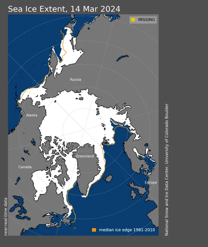
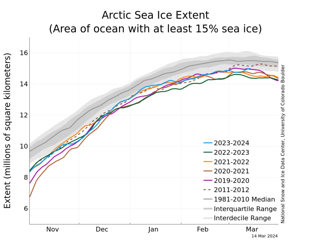
Arctic sea ice has likely reached its maximum extent for the year, at 15.01 million square kilometers (5.80 million square miles) on March 14. The 2024 maximum is the fourteenth lowest in the 46-year satellite record.
Overview of conditions
On March 14, 2024, Arctic sea ice likely reached its maximum extent for the year, at 15.01 million square kilometers (5.80 million square miles), the fourteenth lowest extent in the satellite record. This year’s maximum extent is 640,000 square kilometers (247,000 square miles) below the 1981 to 2010 average maximum of 15.65 million square kilometers (6.04 million square miles) and 600,000 square kilometers (232,000 square miles) above the lowest maximum of 14.41 million square kilometers (5.56 million square miles) set on March 7, 2017.
The date of the maximum this year, March 14, was two days later than the 1981 to 2010 average date of March 12.
Conditions in context
The ice growth season ended with near average sea ice extent in Baffin Bay, average extent in the Bering Sea, above average in the northern portion of the Sea of Okhotsk and Greenland Sea, and below average in the Barents Sea. Extent was well below average in the Gulf of St. Lawrence and the southern portion of the Sea of Okhotsk.
Since the maximum on March 14, extent has dropped about 160,000 square kilometers (62,000 square miles), with losses in the northern portion of the Sea of Okhotsk and the Bering Sea. These losses have been offset by gains in the Barents Sea and Gulf of St. Lawrence.
The downward linear trend in Arctic sea ice maximum extent from1979 to 2024 is 39,800 square kilometers (15,400 square miles) per year, or 2.5 percent per decade relative to the 1981 to 2010 average. Based on the linear trend values, the maximum extent has declined 1.79 million square kilometers (691,000 square miles) since 1979. This is equivalent to the size of Alaska or five times the size of Germany.
Table 1. Ten lowest maximum Arctic sea ice extents (satellite record, 1979 to present)
| Rank | Year | In millions of square kilometers | In millions of square miles | Date |
|---|---|---|---|---|
| 1 | 2017 | 14.41 | 5.56 | March 7 |
| 2 | 2018 | 14.47 | 5.59 | March 17 |
| 3 | 2016 2015 | 14.51 14.52 | 5.60 5.61 | March 23 February 25 |
| 5 | 2023 | 14.62 | 5.64 | March 6 |
| 6 | 2011 2006 | 14.67 14.68 | 5.66 5.67 | March 9 March 12 |
| 8 | 2007 2021 | 14.77 14.78 | 5.70 5.71 | March 12 March 12 |
| 10 | 2019 | 14.82 | 5.72 | March 13 |
For the Arctic maximum, which typically occurs in March, the uncertainty range is ~34,000 square kilometers (13,000 square miles), meaning that extents within this range must be considered effectively equal.

