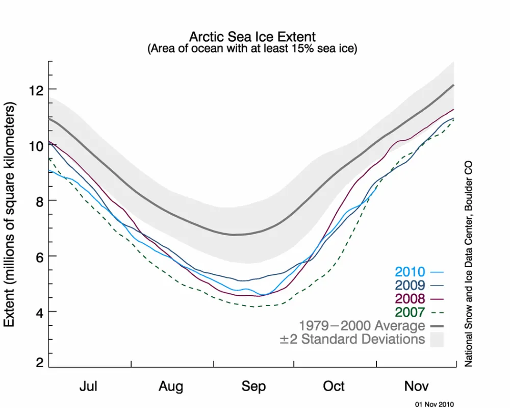
After reaching its minimum extent on September 19, Arctic sea ice grew rapidly through the first half of October before slowing down late in the month. Even with that rapid growth, ice extent for October was the third lowest for that month in the satellite record. Air temperatures in the Arctic were higher than normal.
Overview of conditions
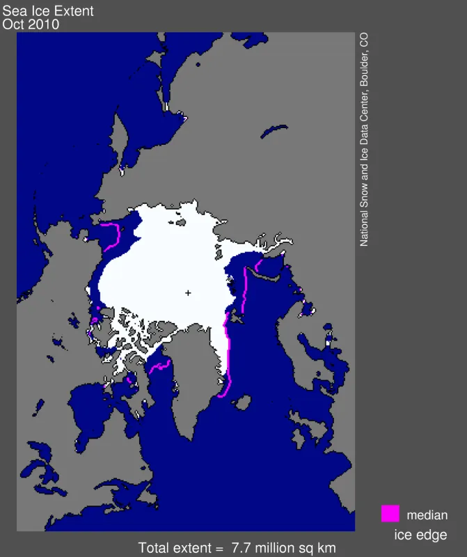
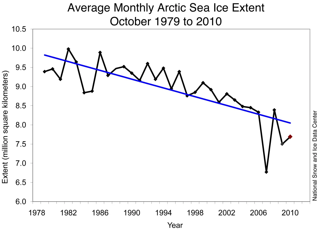
Sea ice extent averaged over October 2010 was the third lowest over the satellite data record at 7.69 million square kilometers (2.97 million square miles). This was 1.60 million square kilometers (618,000 square miles) below the 1979 to 2000 average for October, but 920,000 square kilometers (355,000 square miles) above the record low for the month, which occurred in October 2007.
Conditions in context
Following the minimum ice extent on September 19, the ice cover quickly expanded as polar darkness returned to the Arctic and air temperatures dropped. Ice grew at an average daily rate for the month of October of 92,700 kilometers per day (35,800 square miles per day). This was similar to the growth rate in 2009, but slower than the growth rate following the 2007 and 2008 minimum ice extents. It was slightly faster than the 1979 to 2000 average rate of 82,200 square kilometers (31,700 square miles) per day.
At the end of October, ice growth slowed, and at the end of the month extensive open water areas remained in the Beaufort, Chukchi, Kara and Barents seas. This region had the warmest ocean surface temperatures at the end of the melt season.
October 2010 compared to past years
Even with the rapid ice growth at the beginning of the month, October 2010 had the third-lowest ice extent for the month in the satellite record. The linear trend for October steepened slightly from -5.9% per decade to -6.2% per decade.
Warm air temperatures
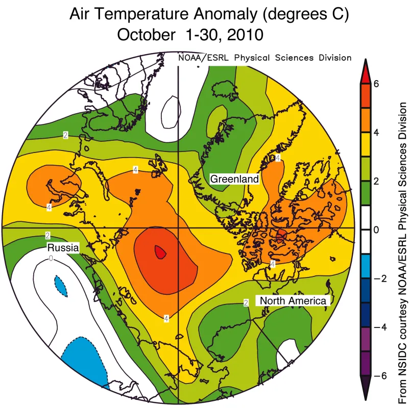
While air temperatures were below freezing over much of the Arctic in October, they were 4 to 6 degrees Celsius (7 to 10 degrees Fahrenheit) higher than normal. The warm conditions resulted partly from regions of open water releasing heat to the atmosphere, and in part from an atmospheric circulation pattern that brought warm air from lower latitudes to the Arctic.
As noted in previous posts, open water in summer absorbs heat from the sun that would normally be reflected back to space by the bright sea ice cover. In order for the ocean to refreeze in autumn, it must first release the heat accumulated during summer in these open water areas to the atmosphere. While the unusually warm temperatures tend to be focused over areas of open water, winds can move this heat around, warming other regions of the Arctic.
Arctic circulation and mid-latitude weather
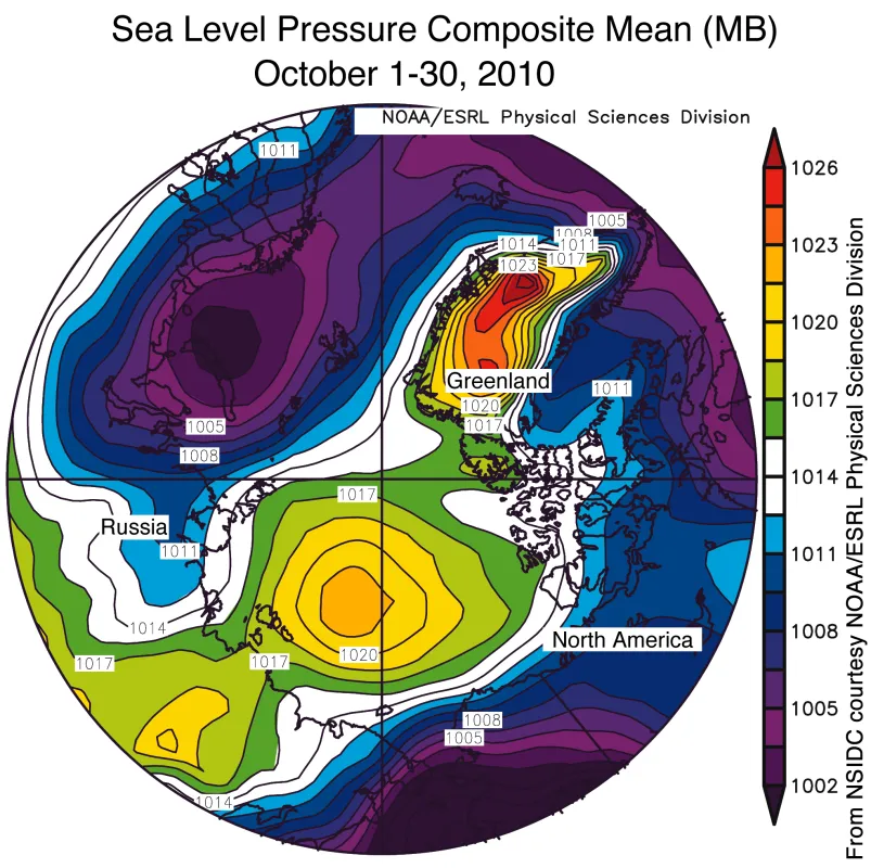
In addition to the effects from open water, weather patterns also contributed to warm conditions in some areas. For most of October, a high-pressure system sat over the Beaufort and Chukchi seas and Greenland, while unusually low pressure dominated the Kara and Barents seas. This pattern resembles the atmospheric pattern observed in October 2009, bringing warm air from lower latitudes to warm the Arctic.
The warming effects of open water, caused by the loss of summer sea ice cover, could add another twist to the warmer Arctic weather trends lately seen in the Arctic. NOAA researcher James Overland recently noted connections between warmer air temperatures in the lower Arctic atmosphere and atmospheric circulation at lower latitudes, in the 2010 NOAA Arctic Report Card.
Further Reading
Screen, J.A. and I. Simmonds, 2010. The central role of diminishing sea ice in recent Arctic temperature amplification. Nature, 464, 1334-1337. doi:10.1038/nature09051. (subscription required)
Serreze, M. C., Barrett, A. P., Stroeve, J. C., Kindig, D. N. & Holland, M. M., 2009. The emergence of surface-based Arctic amplification. Cryosphere 3, 11–19. doi:10.5194/tc-3-11-2009
