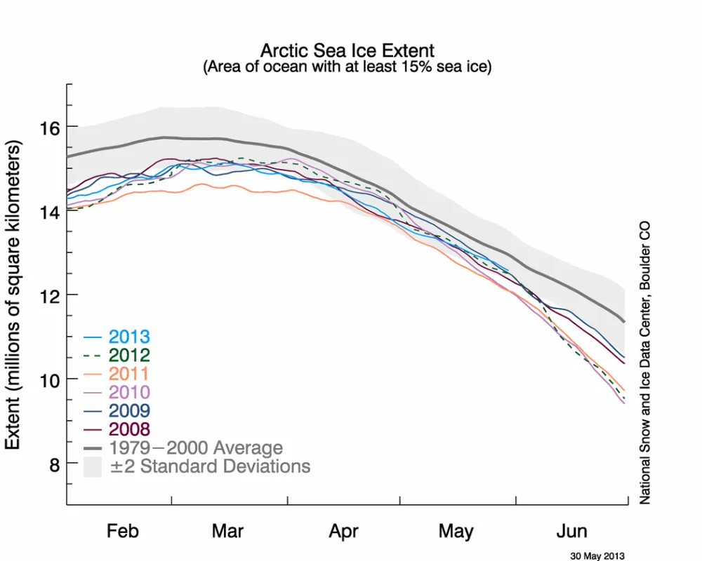
Arctic sea ice extent declined at an approximately average rate through April. While the Arctic Oscillation was in its negative phase for most of winter, in mid April it turned positive. This helped to bring in warm air over Eurasia, although air temperatures over the sea ice cover remain below freezing.
Overview of conditions
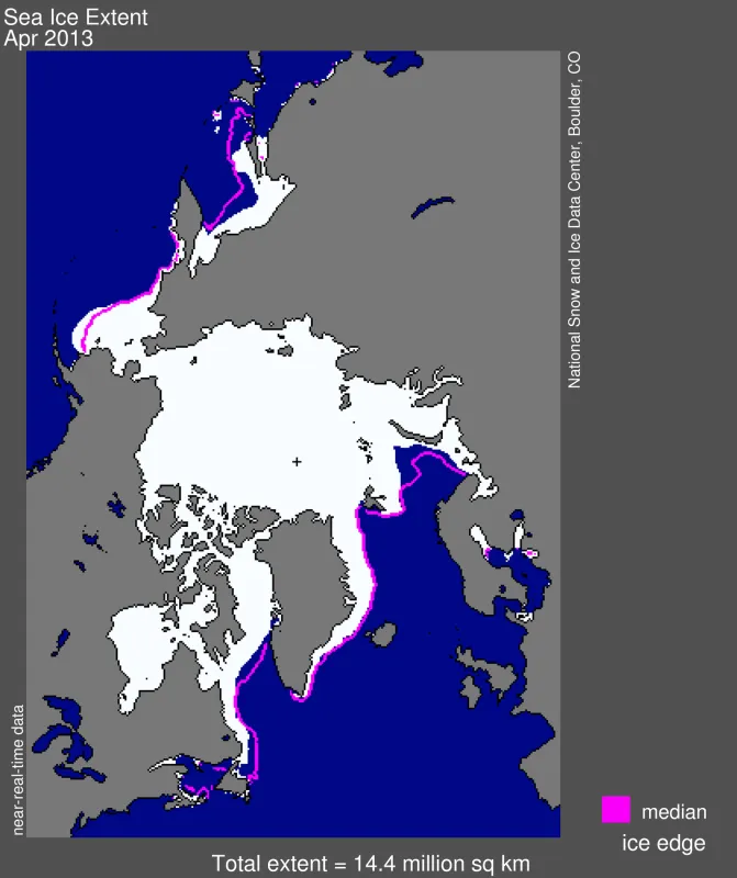
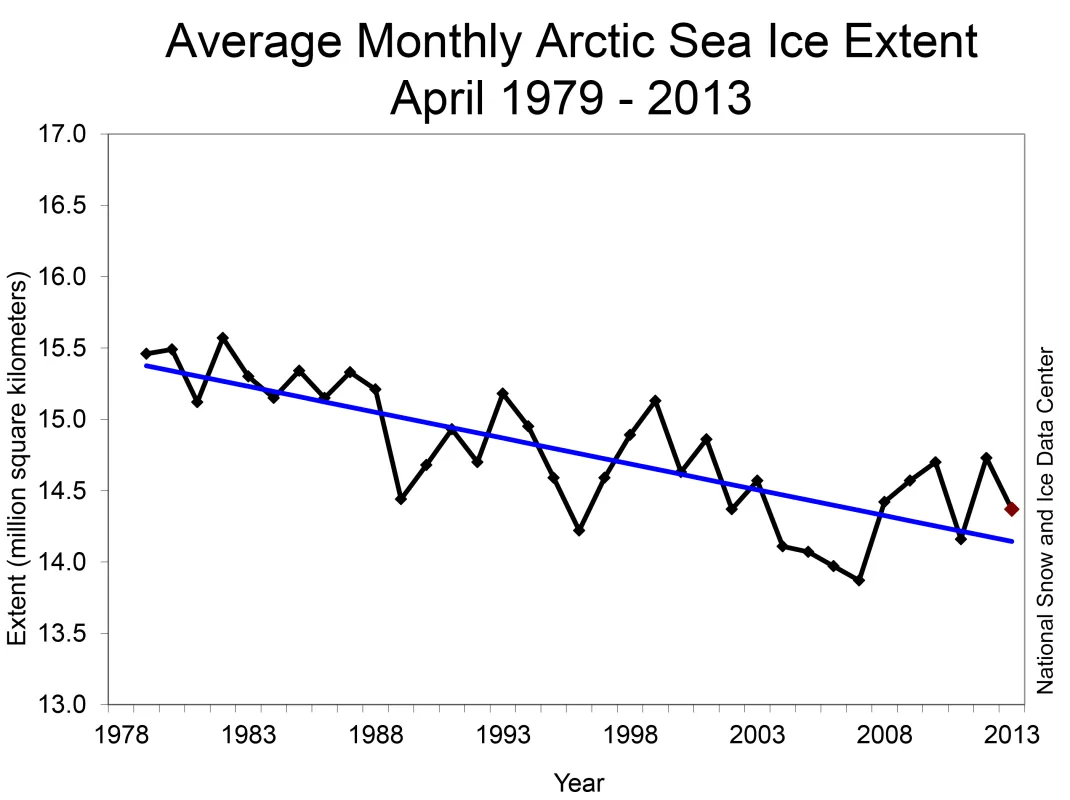
Sea ice extent averaged for the month of April 2013 was 14.37 million square kilometers (5.54 million square miles). This is 630,000 square kilometers (243,000 square miles) below the 1979 to 2000 average for the month, and is the seventh-lowest April extent in the satellite record.
In the earlier part of the satellite data record, average April extent remained above 15 million square kilometers (5.8 million square miles). Since 1989 the extent has mostly remained between 14 and 15 million square kilometers (5.4 and 5.8 million square miles). The years 1993 and 1999 were exceptions, when extent exceeded 15 million square kilometers (5.8 million square miles), as well as 2006 and 2007, when extent dropped below 14 million square kilometers (5.4 million square miles).
A large area of open water has started to form around Franz Josef Land and north of Svalbard. Polynyas are also appearing in the Kara and East Siberian seas.
The walrus and whaling season has begun in Arctic Alaska. The Study of Environmental Arctic Change (SEARCH) Sea Ice for Walrus Outlook (SIWO) is now providing weekly sea ice outlooks as a resource for Alaska Native subsistence hunters, coastal communities, and others interested in sea ice and walrus or whales. With spring sea ice conditions being thinner and less predictable than in the past due to warming in the Arctic, the sea ice outlook helps hunters plan their activities.
Conditions in context
Through the month of April, the Arctic lost 1.5 million square kilometers of ice (444,000 square miles), which is slightly higher than the average for the month. Air temperatures at the 925 hPa level (approximately 3,000 feet above sea level) in April were 5 to 7 degrees Celsius (9 to 13 degrees Fahrenheit) higher than average in the East Siberian Sea and 3 to 5 degrees Celsius (5 to 9 degress Fahrenheit) higher than average in the Kara Sea. Temperatures were 3 to 5 degrees Celsius (5 to 9 degrees Fahrenheit) below average over Alaska. The dominant feature of the Arctic sea level pressure field for April 2013 was unusually high pressure over Alaska and Siberia and below average pressure over the Kara and Barents seas. During the middle of the month, the Arctic Oscillation switched from a negative to a positive phase, with anomalously high sea level pressure over Alaska combined with below average pressure over Greenland and the North Atlantic. This brought in warm air over Eurasia, and above average air temperatures throughout the eastern Arctic.
The reductions in April ice extent this year and over the satellite record are predominantly due to reduced ice cover in the Kara and Barents seas. In contrast, ice extent continues to remain slightly above normal in the Bering Sea.
April 2013 compared to previous years
Average Arctic sea ice extent for April 2013 was the seventh lowest for the month in the satellite record. Through 2013, the linear rate of decline for April ice extent is -2.3 percent per decade relative to the 1979 to 2000 average.
IceBridge Arctic flights
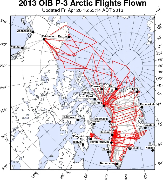
On 20 March 2013, NASA resumed Operation IceBridge aircraft missions over the Arctic. The IceBridge mission was initiated in 2009 to collect airborne measurements of sea ice and ice sheet thickness, to bridge the gap between NASA’s Ice, Cloud and Land Elevation Satellite (ICESat) and the upcoming ICESat-2 mission. This spring, areas not extensively covered in previous campaigns were a focus as well as flight tracks corresponding to the European CryoSat-2 satellite. Several successful flights were flown across the Beaufort and Chukchi seas in March and early April while the aircraft was stationed in Fairbanks, Alaska and Greenland’s Thule Air Base. Afterwards NASA’s P-3B aircraft was moved to Kangerlussuaq, Greenland for flights over the ice sheet. Towards the end of April, the aircraft was once again stationed in Thule, allowing additional ice sheet flights over the north central part of Greenland ice sheet and the resumption of sea ice flights over large portions of Arctic sea ice. The latter included a repeat of a 2012 flight line aimed at sampling a large region of the Canada Basin. This year’s Arctic IceBridge mission ended on 2 May, with the successful completion of ten sea ice and fifteen ice sheet flights.
Earliest satellite maps of Antarctic and Arctic sea ice
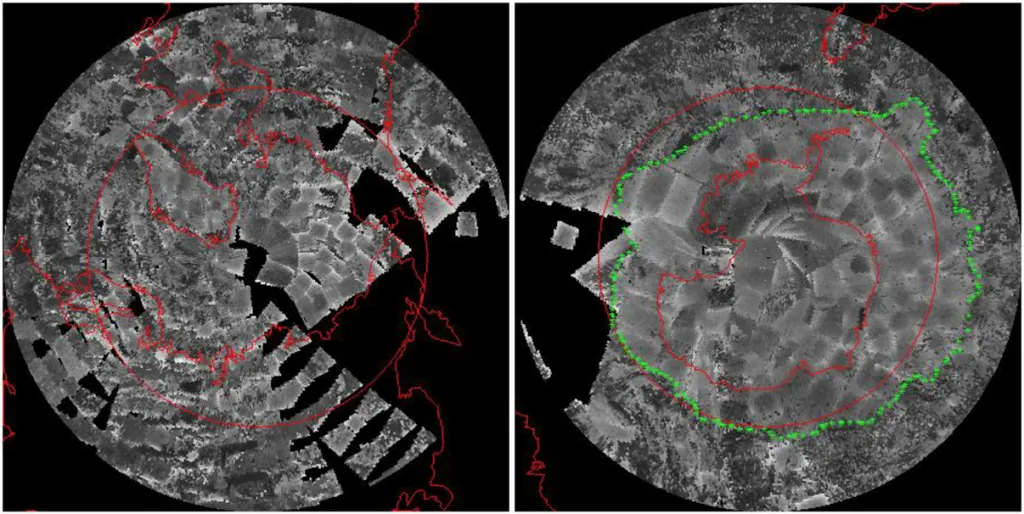
While the modern satellite data record for sea ice begins in late 1978, some data are available from earlier satellite programs. NSIDC has been involved in a project to map sea ice extent using visible and infrared band data from NASA’s Nimbus 1, 2, and 3 spacecraft, which were launched in 1964, 1966, and 1969. Analysis of the Nimbus data has revealed Antarctic sea ice extents that are significantly larger and smaller than seen in the modern 1979 to 2012 satellite passive microwave record. The September 1964 average ice extent for the Antarctic is 19.7 ± 0.3 million square kilometers (7.6 million ± 0.1 square miles. This is more than 250,000 square kilometers (97,000 square miles) greater than the 19.44 million square kilometers (7.51 million square miles) seen in 2012, the record maximum in the modern data record. However, in August 1966 the maximum sea ice extent fell to 15.9 ± 0.3 million square kilometers (6.1 ± 0.1 million square miles). This is more than 1.5 million square kilometers (579,000 square miles) below the passive microwave record low September of 17.5 million square kilometers (6.76 million square miles) set in 1986.
The early satellite data also reveal that September sea ice extent in the Arctic was broadly similar to the 1979 to 2000 average, at 6.9 million square kilometers (2.7 million square miles) versus the average of 7.04 million square kilometers (2.72 million square miles).
In memoriam
We dedicate this post to Dr. Katharine Giles, who was tragically killed cycling to work on 8 April 2013. Together with Dr. Laxon, Katherine Giles worked to retrieve sea ice thickness from satellite radar altimeter data. In 2007 she was the first to show that this data could also be used to show how winds affect the newly exposed Arctic Ocean. Since Dr. Laxon’s death earlier this year, Katharine worked hard to continue his legacy and supervise his students. We have lost yet another talented scientist and a great friend.
Reference
Meier, W. N., D. Gallaher, and G. C. Campbell. 2013. New estimates of Arctic and Antarctic sea ice extent during September 1964 from recovered Nimbus I satellite imagery. The Cryosphere, 7, 699–705 https://doi.org/10.5194/tc-7-699-2013
