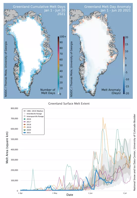
Surface melt and total melt-day area for the Greenland Ice Sheet at the end of the 2021 spring season was below the 1981 to 2010 average. Snowfall and rain (minus runoff) added mass to the ice sheet. As of June 20, total mass gain for the ice sheet since September 2020 was slightly above average. The spike from June 25 to June 27 will be discussed in later a post.
Overview of conditions
The total aerial extent of surface melting (total melt-day extent) through June 20 was just over 2.49 million square kilometers (961,000 square miles), 1.5 times below the 1981 to 2010 average of 3.72 million square kilometers (1.44 million square miles). Melting was slightly below average along the west-central ice sheet, and well below average (10 to 12 days behind the average rate) along the southwestern edge of the ice sheet. Limited areas of the north and northwest had slightly above average melting, but the total extent of these areas was low.
Conditions in context
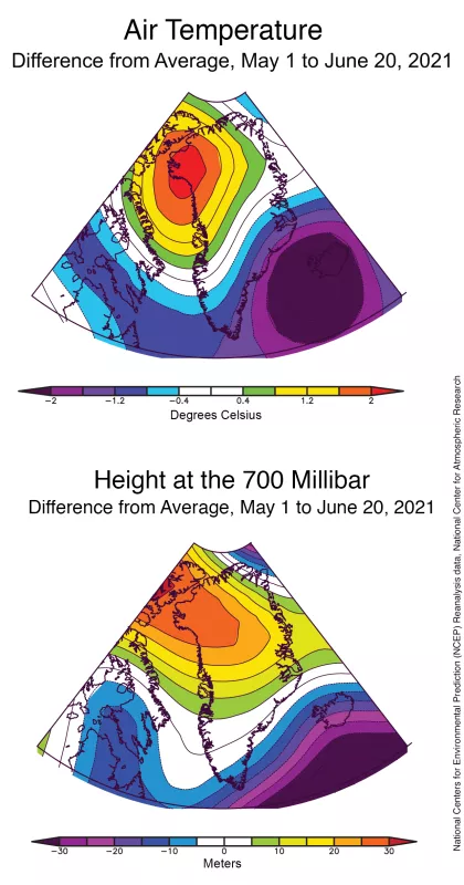
Average air temperature at 700 millibar (about 10,000 feet) and the average height of the 700 millibar level (a measure of air pressure) summarize springtime weather conditions. Air temperatures above Greenland varied across the ice sheet, with warm conditions in the northwest and cool conditions across the southeast. The region near Thule in the northwest was more than 2 degrees Celsius (4 degrees Fahrenheit) above the 1981 to 2010 average, with conditions near the major Helheim Glacier in the southeast were about 2 degrees Celsius (4 degrees Fahrenheit) below average. Air pressure patterns, indicated by the height above average of the 700 millibar level (about 10,000 feet above ground, but higher under high pressure conditions, and lower when low air pressure is present) show an area of moderate high pressure in the northwest of the island and low pressure over the Irminger Sea between Greenland and Iceland.
Greenland is snowy
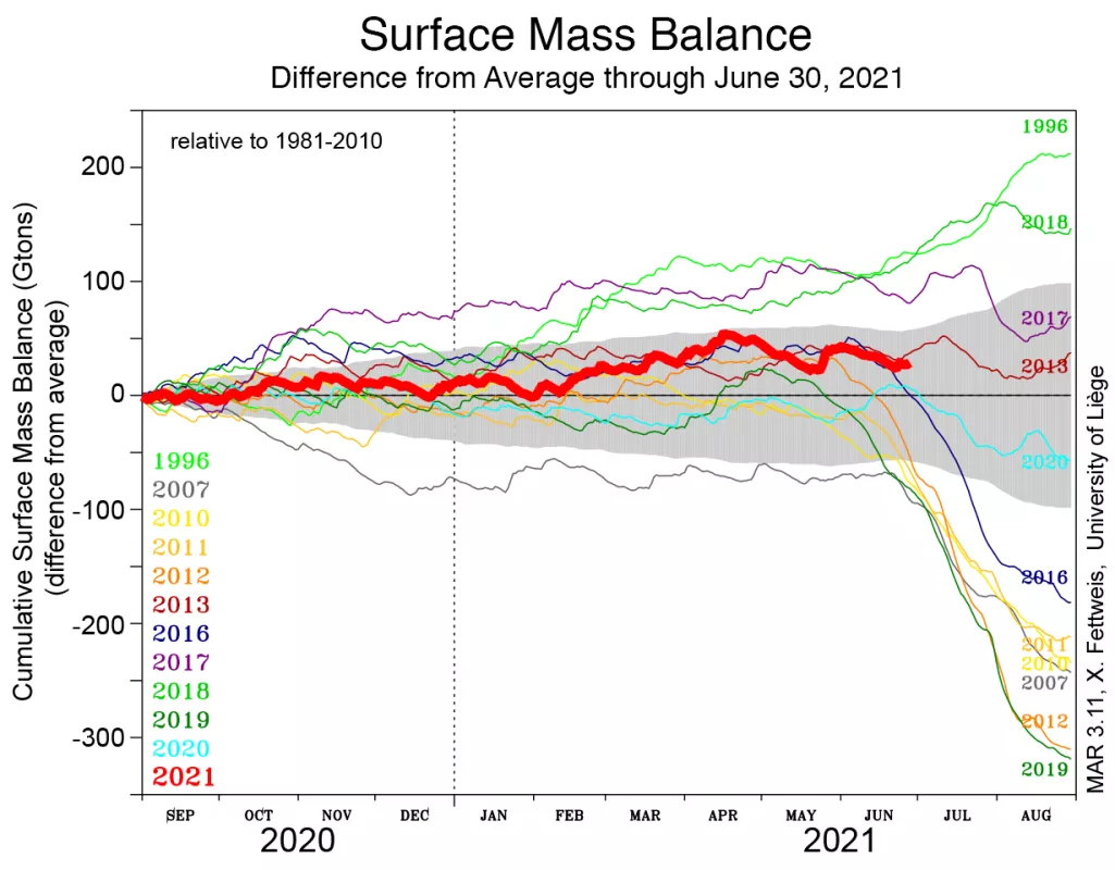
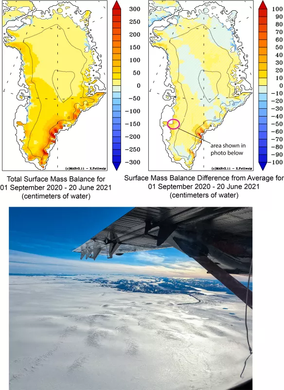
As of June 20, total surface mass balance for the ice sheet was slightly above average total input of snow and rain since September 2020, at about 550 billion tons, 41 billion tons more than average (Figure 3a). Total snowfall was slightly above average for the ice sheet. Areas that received extra snow this year were across the southeast, where some areas saw 50 to 70 centimeters (20 to 28 inches) more snow water equivalent than average, and to a lesser degree along the western coast (Figure 3b). Large areas of the central and northeastern ice sheet were near-average for the year so far. Surface mass balance over the ice sheet from September 1, 2020, to June 20, 2021, was about 8 percent above the 1981 to 2010 average, with 7 percent above average snowfall and 10 percent below average melt runoff.
Greenland is bright
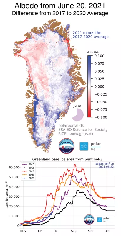
Using the European Space Agency (ESA) Sentinel-3 satellite Ocean and Land Colour Instrument (OLCI), Greenland’s snow and ice albedo, or net reflectivity, tracked on a daily basis at a resolution of 300 meters (about 1,000 feet). This product is now available from the Danish Greenland Geological Survey (GEUS). The map for June 20 shows a slightly darker surface over a broad region of the northwestern ice sheet, with narrow areas of much darker surface near the coast where above average melting and runoff has occurred. Most of the central western ice edge and southwest ice edge, where ablation areas or exposed ice occur, was considerably brighter than average (blue areas). This region is usually much wider at this point in the season but is still covered by some snow from the past winter, as shown in the Figure 3b photograph. The extent of bare ice exposure is tracking near the lowest levels for the last five years except 2018, which was an especially snowy and low-melt year.
Further reading
Amory, C., C. Kittel, L. Le Toumelin, C. Agosta, A. Delhasse, V. Favier, X. and Fettweis. 2021. Performance of MAR (v3.11) in simulating the drifting-snow climate and surface mass balance of Adélie Land, East Antarctica, Geoscientific Model Development, 14, 3487–3510, doi:10.5194/gmd-14-3487-2021.
