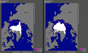
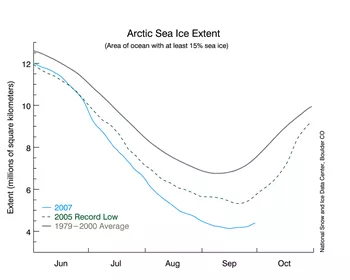
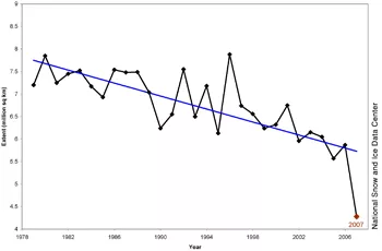
Arctic sea ice during the 2007 melt season plummeted to the lowest levels since satellite measurements began in 1979. The average sea ice extent for the month of September was 4.28 million square kilometers (1.65 million square miles), the lowest September on record, shattering the previous record for the month, set in 2005, by 23 percent (see Figure 1). At the end of the melt season, September 2007 sea ice was 39 percent below the long-term average from 1979 to 2000 (see Figure 2). If ship and aircraft records from before the satellite era are taken into account, sea ice may have fallen by as much as 50 percent from the 1950s. The September rate of sea ice decline since 1979 is now approximately 10 percent per decade, or 72,000 square kilometers (28,000 square miles) per year (see Figure 3).
Arctic sea ice has long been recognized as a sensitive climate indicator. NSIDC Senior Scientist Mark Serreze said, “Computer projections have consistently shown that as global temperatures rise, the sea ice cover will begin to shrink. While a number of natural factors have certainly contributed to the overall decline in sea ice, the effects of greenhouse warming are now coming through loud and clear.”
One factor that contributed to this fall’s extreme decline was that the ice was entering the melt season in an already weakened state. NSIDC Research Scientist Julienne Stroeve said, "The spring of 2007 started out with less ice than normal, as well as thinner ice. Thinner ice takes less energy to melt than thicker ice, so the stage was set for low levels of sea ice this summer.”
Another factor that conspired to accelerate the ice loss this summer was an unusual atmospheric pattern, with persistent high atmospheric pressures over the central Arctic Ocean and lower pressures over Siberia. The scientists noted that skies were fairly clear under the high-pressure cell, promoting strong melt. At the same time, the pattern of winds pumped warm air into the region. While the warm winds fostered further melt, they also helped push ice away from the Siberian shore. NSIDC Research Scientist Walt Meier said, "While the decline of the ice started out fairly slowly in spring and early summer, it accelerated rapidly in July. By mid-August, we had already shattered all previous records for ice extent."
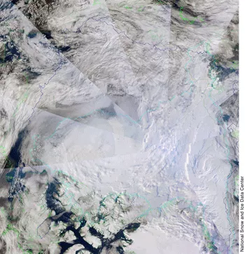
Arctic sea ice receded so much that the fabled Northwest Passage completely opened for the first time in human memory (see Figure 4). Explorers and other seafarers had long recognized that this passage, through the straits of the Canadian Arctic Archipelago, represented a potential shortcut from the Pacific to the Atlantic. Roald Amundsen began the first successful navigation of the route starting in 1903. It took his group two-and-a-half years to leapfrog through narrow passages of open water, with their ship locked in the frozen ice through two cold, dark winters. More recently, icebreakers and ice-strengthened ships have on occasion traversed the normally ice-choked route. However, by the end of the 2007 melt season, a standard ocean-going vessel could have sailed smoothly through. On the other hand, the Northern Sea Route, a shortcut along the Eurasian coast that is often at least partially open, was completely blocked by a band of ice this year.
In addition to the record-breaking retreat of sea ice, NSIDC scientists also noted that the date of the lowest sea ice extent, or the absolute minimum, has shifted to later in the year. This year, the five-day running minimum occurred on September 16, 2007; from 1979 to 2000, the minimum usually occurred on September 12. NSIDC Senior Scientist Ted Scambos said, “What we’ve seen this year fits the profile of lengthening melt seasons, which is no surprise. As the system warms up, spring melt will tend to come earlier and autumn freezing will begin later.”
Changes in sea ice extent, timing, ice thickness, and seasonal fluctuations are already having an impact on the people, plants, and animals that live in the Arctic. NSIDC Research Scientist and Arctic resident Shari Gearheard said, “Local people who live in the region are noticing the changes in sea ice. The earlier break up and later freeze up affect when and where people can go hunting, as well as safety for travel.”
NSIDC scientists monitor and study Arctic sea ice year round, analyzing satellite data and seeking to understand the regional changes and complex feedbacks that we are seeing. Serreze said, “The sea ice cover is in a downward spiral and may have passed the point of no return. As the years go by, we are losing more and more ice in summer, and growing back less and less ice in winter. We may well see an ice-free Arctic Ocean in summer within our lifetimes.” The scientists agree that this could occur by 2030. Serreze concluded, “The implications for global climate, as well as Arctic animals and people, are disturbing."
Related Resource
NASA Images Release
'Remarkable' Drop in Arctic Sea Ice Raises Questions
References
Meier, W.N., J. Stroeve, and F. Fetterer, 2007. Whither Arctic sea ice? A clear signal of decline regionally, seasonally and extending beyond the satellite record, Ann. Glaciol., vol. 46, pp. 428-434.
Serreze, M.C., M.M. Holland, and J. Stroeve, 2007. Perspectives on the Arctic's shrinking sea-ice cover, Science, vol. 315, pp. 1533-1536, doi: 10.1126/science.1139426.
Stroeve J., M.M. Holland, W. Meier, T. Scambos, and M. Serreze, 2007. Arctic sea ice decline: Faster than forecast, Geophys. Res. Lett., vol. 34, L09501, doi: 10.1029/2007GL029703.


