What features can I detect in the RAMP AMM-1 SAR image mosaic of Antarctica?
A variety of features can be detected in the RAMP image mosaic. SAR data allow ready discrimination between areas of high snow accumulation, crevassed regions, and areas susceptible to seasonal melt. Field camps and features such as runways and heavily traveled snowmobile tracks are also visible. The collection of images below demonstrates the degree of detail provided by the RAMP image mosaic. Please note the white and/or blue colors used in the annotations on the images are simply for better contrast against the background and have no other significance.
Please note: AMM-1 data are copyrighted by the Canadian Space Agency (CSA). The images displayed below are derived from a 125-meter version of the mosaic. Use of higher resolution data requires special authorization from NASA.
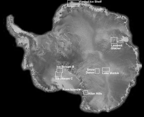
Overview of the locations of each image
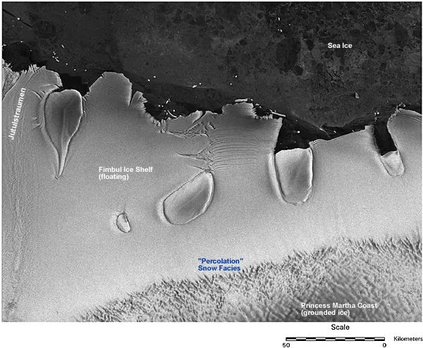
Fimbul Ice Shelf
The Fimbul Ice Shelf is a thick slab of glacier ice floating on the ocean. Large ice shelves are unique to the Antarctic. The Fimbul Ice Shelf is punctuated by numerous ice rises that occur where isolated rocky islands are covered by ice. Ice shelves may be particularly sensitive to changes in climate, and recently ice shelves in the Antarctic Peninsula have experienced rapid retreat. The Fimbul Ice Shelf, situated at about the same latitude as the Peninsula shelves, has remained relatively stable for at least 30 years.
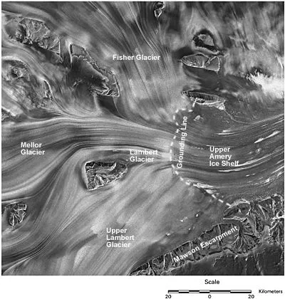
Lambert Glacier
Lambert Glacier is one of the world's largest and longest glaciers, covering over 1 million square kilometers along a length of over 400 kilometers. It drains a substantial portion of East Antarctica into the Amery Ice Shelf. The upper reaches of the glacier are characterized by a sinuous confluence of tributary glaciers funneled northward by the Mawson Escarpment. The grounding line, indicating the zone where the ice begins to float, was determined by Fricker (1998).
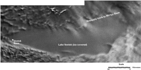
Lake Vostok
Lake Vostok is a huge freshwater lake buried beneath approximately 3,800 meters of ice. The extent of the sub-glacier lake is shown by a region of extremely low relief in the ice surace. The lake is sustained by a combination of geothermal heat and the insulating properties of the polar ice sheet. Vostok Station is located on the southern tip of the lake and is the site of a drilling effort that will soon permit exploration in search of life in this extreme environment.
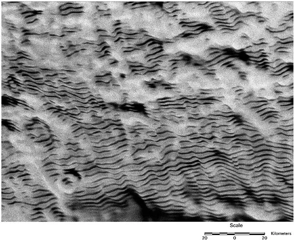
Snow Dunes
Extensive snow dunes wrinkle the surface of large parts of East and West Antarctica. The dunes are up to 100 kilometers long and separated by 2 to 4 kilometers, but only a few meters high. Comparison of modern satellite images with images acquired four decades earlier reveals that the dunes are nearly motionless. The dunes are unique in that they appear not to be formed by normal wind deposition, but rather by ablation due to wave patterns set up in katabatic winds. The linear pattern is due to backscatter variations associated with grain-size changes across dunes.
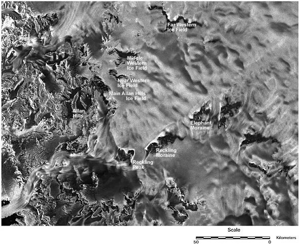
Allan Hills
The Allan Hills are located on the flanks of the TransAntarctic Mountains. Ice upwells onto the hills where combinations of winds and solar insolation cause the ice to quickly ablate. Left behind are meteorites that once fell over a large region of East Antarctica but have been carried by glacier motion into this small locality. Many important meteorite specimens have been found in the Allan Hills including the ALH 84001 meteorite containing unusual structures that some scientists suspected were Martian microfossils.
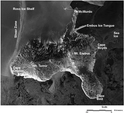
Ross Island
Ross Island is the site of the United States McMurdo Station, the largest research base in Antarctica. The station is located on the tip of Hut Point Peninsula and the road and skiway of Williams Field are visible on the flat ice of the McMurdo Ice Shelf. Ross Island was formed by volcanic activity. Mt. Erebus, the largest peak on the island, is one of several active volcanoes in Antarctica.
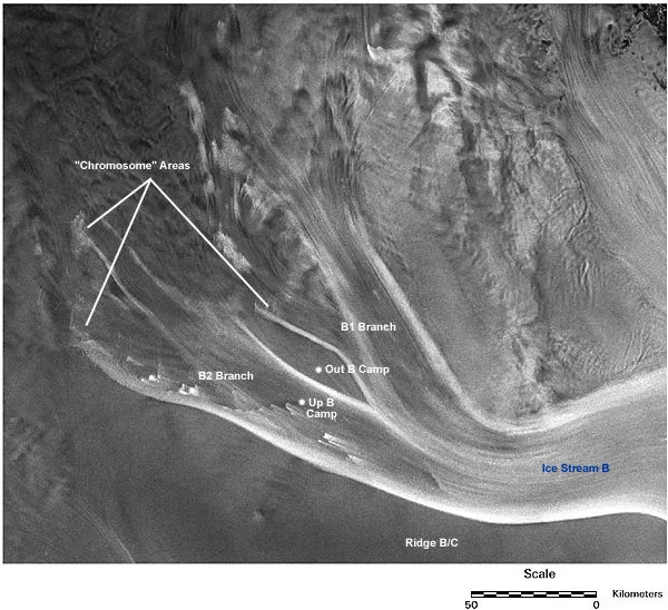
Ice Stream B
One of the most studied and interesting ice streams in Antarctica, Ice Stream B shows a number of features that indicate past changes and ongoing evolution. In this subscene the upstream ends of several ice stream shear margins are highlighted. Characteristic crevasse patterns, nicknamed "chromosomes," mark the ends of several of these margin traces. These features have been shown to result from upstream migration of the ice stream. The former research camp, UpB (or "Upstream Bravo"), is visible near the center of the northern branch of the stream (south is up in the image).
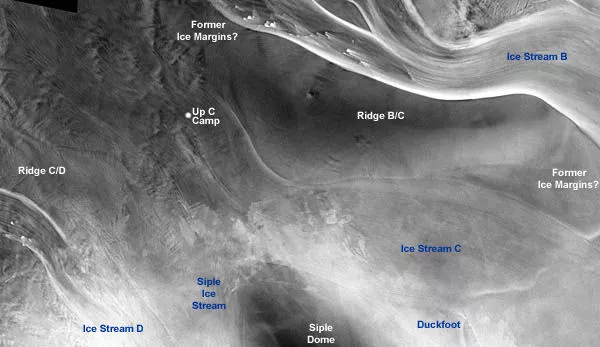
Ice Stream C
This subscene shows a variety of relict features in the ice sheet, attesting to the rapid evolution of ice stream systems relative to most outlet glacier systems. Ice Stream C is flanked by several faint traces marking known or suspected former ice stream shear margins. At the upstream end of the ridge separating Ridge B/C (upper left in the image) several faint traces are intersected by the active shear margin of B, suggesting that flow in this area has recently reorganized. Just below this area, the runways of the former camp UpC (or "Upstream Charlie") are visible.
