The search for data can be daunting, but there are tools available to help you along the way. The purpose of this article is to describe two web-based tools, NASA’s Worldview and Earthdata Search, which can be used to work with datasets collected from NASA satellite missions. The tools can complement one another when searching for and visualizing some data, but are intended to serve different needs. Both tools can be used with a number of datasets available at NSIDC[1]. To illustrate the use of these tools, a fictional case study is presented, displaying how these web interfaces may be used in practice. The first tool in this discussion is NASA Worldview. The Worldview tool is intended to serve as a platform to browse global satellite data in a near-real time setting. For many of the datasets available through Worldview, the latency (time difference between acquisition and availability) is on the order of just a few hours. Therefore, Worldview was designed to meet the needs of those with time-critical roles, but can also be useful for visualizing and inspecting data prior to downloading. For more guidance on using Worldview, please have a look at the NSIDC video tutorial, showing users how to view and download Soil Moisture Active Passive (SMAP) data available from NSIDC, or visit the NASA Worldview FAQ Page. The second tool available to data users is NASA Earthdata Search. The Earthdata Search tool is intended to provide more thorough and detailed data ordering options. Many of the datasets accessible with this tool have the EOSDIS Service Interface (ESI) enabled, allowing a user to configure the data to match their spatial and temporal needs, the formats and projections to align with their software preferences, and access options appropriate for the volume of data ordered. Therefore, Earthdata Search is designed with a focus on data acquisition for research rather than browsing and monitoring, though some visualization is possible. For more guidance on using Earthdata Search, please have a look at the NSIDC video tutorial, showing users how to search for and order SMAP data available from NSIDC.
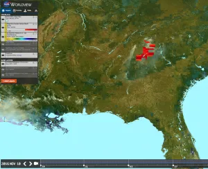
Fictional Tool Selection Case Study: Fire Service Incident Command Systems Data and Tool Need #1: “As a fire service emergency first responder to the November 2016 wildfires in Northern Georgia, I need to know: a) where smoke plumes are traveling, b) where the density of those plumes reaches a hazardous threshold, c) current soil moisture, and d) any accessible large bodies of water to help fight the fire source.” In this scenario using the NASA Worldview tool would be the optimum choice. The responder would have the ability to view visible imagery showing the plume trajectory and SMAP soil moisture, overlay an aerosol optical depth product for analyzing plume density, and could add Base Layers to show large bodies of water (Figure 1).
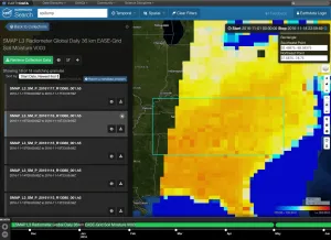
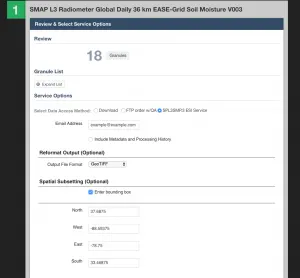
Data and Tool Need #2: “As a fire service emergency manager, I would like to commission a study looking at conditions which preceded the fires, so as to prepare for similar scenarios in the future. I need to analyze the soil moisture conditions for the three weeks leading up to the fires.” In this case, using the NASA Earthdata Search tool is the best choice. The emergency manager will be able to search for a soil moisture product using temporal and spatial bounds (Figure 2), reformat the data if needed, subset using the bounds entered in the search tool (Figure 3), and choose a preferred download method (e.g. FTP pull, download links, download scripts).
NSIDC recommendations: For visualizing near-real time data, look no further than NASA Worldview. The data are still available for download, and maps can be shared as a URL or acquired in a variety of image formats. You may still have quick visualization options for your data in Earthdata Search, but the value of the Earthdata search tool is configuring the data to save you time in your research-oriented analyses. [1] The datasets available with these online tools will have a link on the NSIDC dataset landing page.


